
    |
 |
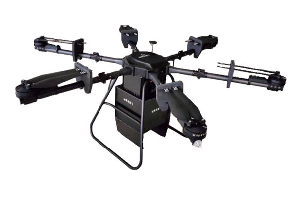
| ˇŇĂÇŃ´äÎŕ»ÍĂěĘ໡µĂŃÁ UAV hyperspectral Measurement FS60 series (CHN) ˇŇĂÇŃ´äÎŕ»ÍĂěĘ໡µĂŃÁ UAV hyperspectral Measurement FS60 series (CHN) ´éÇ¡ŇĂÇŃ´˘éÍÁŮĹŔŇľĘ໡µĂŃÁ˘Í§ľ×Ş áËĹ觹éÓ ´Ôą áĹĐÇѵ¶Řľ×éą´ÔąÍ×čąć áşşŕĂŐÂĹä·Áě ˘éÍÁŮŴѧˇĹčŇǨж١ąÓä»ăŞéˇŃşˇŇĂŕˇÉµĂ·ŐčáÁčąÂÓ ˇŇĂ»ĂĐŕÁÔąˇŇĂŕ¨ĂÔŕµÔşâµ˘Í§ľ×ŞáĹĐĽĹĽĹÔµ ˇŇõԴµŇÁČѵĂپת㹻čŇáĹСŇõĂǨĘÍşäż ˇŇõĂǨĘÍşáąÇŞŇ½Ńč§áĹĐĘŔŇľáÇ´ĹéÍÁ·Ň§·ĐŕĹ ·ĐŕĹĘŇşáĹĐĹŘčÁąéÓ ˇŇõĂǨĘÍşĘŔŇľáÇ´ĹéÍÁ ĎĹĎ
FS 60 UAV hyperspectral measurement system adopts high signal-to-noise ratio and ultra-high-speed CCD imaging device to provide highly stable spectral image acquisition; the self-developed high-efficiency and low-power image processing algorithm greatly extends the flight time of the whole aircraft and reduces the power consumption of the system.
Through real-time measurement of spectral image information of plants, water bodies, soil and other ground objects, it is applied to precision agriculture, crop growth and yield evaluation, forest pest monitoring and fire monitoring, coastline and marine environment monitoring, lake and watershed environment monitoring, etc.
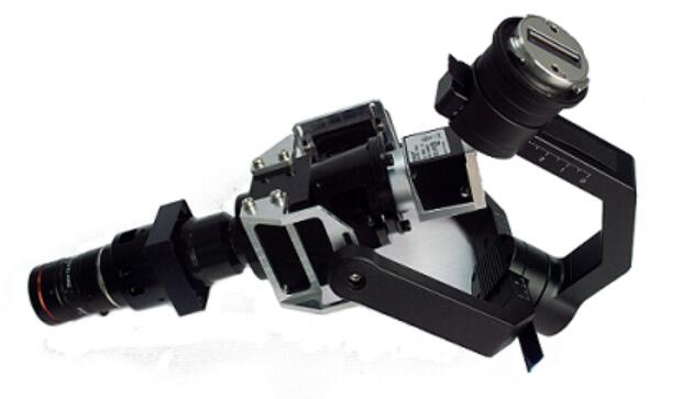
The system is compact in design and the imaging spectrometer host has high spectral resolution. The whole machine consists of: high stability head, hyperspectral imager, large capacity storage system, wireless image system, GPS navigation system, ground receiving workstation and ground control system.
Hyperspectral camera features
UAV features
Measurement characteristics of airborne system
Application area
Instrument features of FS-60 UAV Hyperspectral Measurement System
Easy to operate, no need for a professional drone operator, and can be operated by one person.
Technical parameters of FS-60 UAV Hyperspectral Measurement System
Standard Accessories of FS-60 UAV Hyperspectral Measurement System
Application of FS-60 UAV Hyperspectral Measurement System |
 GA-Great20 FT-IR Fourier Transform Infrared Spectrometer Spectro Meter ŕ¤Ă×čͧÇŃ´ŕ©´ĘŐ YS4582 TOMATO (3nh) ŕ¤Ă×čͧÇŃ´ŕ©´ĘŐáşşµŃé§âµęĐ High-precision Spectrophotometer PS808CT (3nh) ŕ¤Ă×čͧÇŃ´ŕ©´ĘŐáşşµŃé§âµęĐ Large Aperture Spectrophotometer PS809 (3nh) ŕ¤Ă×čͧÇŃ´ŕ©´ĘŐáşşµŃé§âµęĐ Particle Spectrophotometer PS808 (3nh) NipponDenshoku Model NF-333ŕ¤Ă×čͧÇŃ´¤čŇĘŐáşşÍѵâąÁŃµÔ Spectrophotometers&Color Spectrophotometer ŕ¤Ă×čͧÇŃ´ŕ©´ĘŐ DC-50 Series ŕ¤Ă×čͧÇŃ´ŕ©´ĘŐ Colorimeter DS 528 Series (CHN) Benchtop Spectrophoto Meter ŕ¤Ă×čͧÇŃ´ŕ©´ĘŐáşşµŃé§âµęĐ ITK-YS6003 ŕ¤Ă×čͧÇŃ´ŕ©´ĘŐ Colorimeter PS-2070-PS2080 Series (3nh) ŕ¤Ă×čͧÇŃ´ŕ©´ĘŐ Colorimeter PS-2050-PS2060 Series (3nh) ŕ¤Ă×čͧÇŃ´ŕ©´ĘŐ Colorimeter PS-2030-PS2040 Series (3nh) Color spectrum desktop liquid colorimeter DS-812N / DS-816N ˇŇĂÇŃ´äÎŕ»ÍĂěĘ໡µĂŃÁ UAV Near-Infrared hyperspectral Measurement FS63 series (CHN) ŕ¤Ă×čͧ·´ĘÍşŕ©´ĘŐ Imaging hyperspectral camera FS2X series (CHN) ŕ¤Ă×čͧ·´ĘÍşŕ©´ĘŐ Portable Transmittance Tester CT-Series (CHN) ŕ¤Ă×čͧ·´ĘÍşŕ©´ĘŐ DS-1000 Series Spectrophotometer (CHN) ŕ¤Ă×čͧ·´ĘÍşŕ©´ĘŐ Spectral Colorimeter CR series (CHN) ŕ¤Ă×čͧ·´ĘÍşŕ©´ĘŐ DS-700-C Series Spectrophotometer (CHN) Bench-top spectrophotometer ŕ¤Ă×čͧÇŃ´ŕ©´ĘŐáşşµŃé§âµęĐ DS-D Series PS20 series Spectrocoloriemter ŕ¤Ă×čͧÇŃ´ŕ©´ĘŐ(3NH) DS-200 Colorimeter ŕ¤Ă×čͧÇŃ´ŕ»ĂŐÂşŕ·ŐÂşĘŐ (CHN) Spectroscopic Chromatography CR8+ DS-600 Spectrophotometer ŕ¤Ă×čͧÇŃ´ŕ©´ĘŐ (CHN) Color Sensor CRX-50 ˇĹéͧ·´ĘÍşĘčͧŕ·ŐÂşŕ©´ĘŐ ŕ¤Ă×čͧ·´ĘÍşŕ©´ĘŐ DS-700Series Spectrophotometer (CHN) ˇĹéͧ¶čŇÂŔŇľÇŃ´ŕ©´ĘŐ Hyperspectral Figspectral-FS Series Spectrophoto Meter ŕ¤Ă×čͧÇŃ´ŕ©´ĘŐµŃé§âµęĐ CS-826 (CHN) Spectrophoto Meter ŕ¤Ă×čͧÇŃ´ŕ©´ĘŐµŃé§âµęĐ CS-828 (CHN) Spectrophoto Meter ŕ¤Ă×čͧÇŃ´ŕ©´ĘŐ CS-420 (CHN) Colormeter Pro ŕ¤Ă×čͧŕ»ĂŐÂşŕ·ŐÂşĘŐ Colormeter CMYK (CHN) Colorimeter ŕ¤Ă×čͧŕ»ĂŐÂşŕ·ŐÂşĘŐ CS-410 (CHN) Spectrophoto Meter ŕ¤Ă×čͧÇŃ´ŕ©´ĘŐ CS-392 (CHN) Spectrophoto Meter ŕ¤Ă×čͧÇŃ´ŕ©´ĘŐ CS-500-SERIES (CHN) Spectrophoto Meter ŕ¤Ă×čͧÇŃ´ŕ©´ĘŐ TS70-SERIES (3NH) Colormeter Pro ŕ¤Ă×čͧŕ»ĂŐÂşŕ·ŐÂşĘŐ Colormeter Pro (CHN) Spectrophoto Meter ŕ¤Ă×čͧÇŃ´ŕ©´ĘŐ YD5050(3NH) Spectrophoto Meter ŕ¤Ă×čͧÇŃ´ŕ©´ĘŐ YS4580(3NH) Colorimeter ŕ¤Ă×čͧŕ»ĂŐÂşŕ·ŐÂşĘŐ CS-280 Colorimeter ŕ¤Ă×čͧŕ»ĂŐÂşŕ·ŐÂşĘŐ CS-260 Colorimeter ŕ¤Ă×čͧŕ»ĂŐÂşŕ·ŐÂşĘŐ CS-220 Colorimeter ŕ¤Ă×čͧŕ»ĂŐÂşŕ·ŐÂşĘŐ CS-210 Colorimeter ŕ¤Ă×čͧŕ»ĂŐÂşŕ·ŐÂşĘŐ CS-200 Colorimeter ŕ¤Ă×čͧŕ»ĂŐÂşŕ·ŐÂşĘŐ CS-10 Spectrophoto Meter ŕ¤Ă×čͧÇŃ´ŕ©´ĘŐ CM-200S Spectrophoto Meter ŕ¤Ă×čͧÇŃ´ŕ©´ĘŐáşşµŃé§âµęĐ CS-820N Spectrophoto Meter ŕ¤Ă×čͧÇŃ´ŕ©´ĘŐ ITK-YS3060 Spectrophoto Meter ŕ¤Ă×čͧÇŃ´ŕ©´ĘŐ ITK-YS3010 Spectrophoto Meter ŕ¤Ă×čͧÇŃ´ŕ©´ĘŐáşşµŃé§âµęĐ ITK-YS6060 Spectrophoto Meter ŕ¤Ă×čͧÇŃ´ŕ©´ĘŐáşşµŃé§âµęĐ ITK-YS6010 Spectrophotometer ŕ¤Ă×čͧÇŃ´ŕ©´ĘŐ CS-390 Three Angles Color Spectrophotometer ŕ¤Ă×čͧÇŃ´ŕ©´ĘŐ CS-600CG Color and Haze ŕ¤Ă×čͧÇŃ´ĘŐáĹĐËÁ͡¤ÇŃą CS-700 áĹĐ CS-720 Spectrophotometer ŕ¤Ă×čͧÇŃ´ŕ©´ĘŐáşşµŃé§âµęĐ CS-810 Spectro Photo Meter ŕ¤Ă×čͧÇŃ´ŕ©´ĘŐáşşµŃé§âµęĐ Model CS-801 Spectrophotometer ŕ¤Ă×čͧÇŃ´ŕ©´ĘŐ CS-801 Spectrophotometer ŕ¤Ă×čͧÇŃ´ŕ©´ĘŐ SC-20 Spectrophotometer ŕ¤Ă×čͧÇŃ´ŕ©´ĘŐ SC-80 Spectro Photo Meter ŕ¤Ă×čͧÇŃ´ŕ©´ĘŐáşşąéÓ Model CS-800 Spectrophotometer ŕ¤Ă×čͧÇŃ´ŕ©´ĘŐĽ§ Model CS 600 Spectrophotometer ŕ¤Ă×čͧÇŃ´ŕ©´ĘŐ áşşŕ»Ő¡ Model CS 820 Spectrophotometer ŕ¤Ă×čͧÇŃ´ŕ©´ĘŐ Model NH 300 Spectrophotometer NR-110 Spectrophotometer ŕ¤Ă×čͧÇŃ´ŕ©´ĘŐ NR-200 Spectrophotometer ŕ¤Ă×čͧÇŃ´ŕ©´ĘŐ NH-310 Spectrophotometer ŕ¤Ă×čͧÇŃ´ŕ©´ĘŐ NS-800 GA-Great20 FT-IR Fourier Transform Infrared Spectrometer Spectro Meter ŕ¤Ă×čͧÇŃ´ŕ©´ĘŐ YS4582 TOMATO (3nh) ŕ¤Ă×čͧÇŃ´ŕ©´ĘŐáşşµŃé§âµęĐ High-precision Spectrophotometer PS808CT (3nh) ŕ¤Ă×čͧÇŃ´ŕ©´ĘŐáşşµŃé§âµęĐ Large Aperture Spectrophotometer PS809 (3nh) ŕ¤Ă×čͧÇŃ´ŕ©´ĘŐáşşµŃé§âµęĐ Particle Spectrophotometer PS808 (3nh) NipponDenshoku Model NF-333ŕ¤Ă×čͧÇŃ´¤čŇĘŐáşşÍѵâąÁŃµÔ Spectrophotometers&Color Spectrophotometer ŕ¤Ă×čͧÇŃ´ŕ©´ĘŐ DC-50 Series ŕ¤Ă×čͧÇŃ´ŕ©´ĘŐ Colorimeter DS 528 Series (CHN) Benchtop Spectrophoto Meter ŕ¤Ă×čͧÇŃ´ŕ©´ĘŐáşşµŃé§âµęĐ ITK-YS6003 ŕ¤Ă×čͧÇŃ´ŕ©´ĘŐ Colorimeter PS-2070-PS2080 Series (3nh) ŕ¤Ă×čͧÇŃ´ŕ©´ĘŐ Colorimeter PS-2050-PS2060 Series (3nh) ŕ¤Ă×čͧÇŃ´ŕ©´ĘŐ Colorimeter PS-2030-PS2040 Series (3nh) Color spectrum desktop liquid colorimeter DS-812N / DS-816N ˇŇĂÇŃ´äÎŕ»ÍĂěĘ໡µĂŃÁ UAV Near-Infrared hyperspectral Measurement FS63 series (CHN) ŕ¤Ă×čͧ·´ĘÍşŕ©´ĘŐ Imaging hyperspectral camera FS2X series (CHN) ŕ¤Ă×čͧ·´ĘÍşŕ©´ĘŐ Portable Transmittance Tester CT-Series (CHN) ŕ¤Ă×čͧ·´ĘÍşŕ©´ĘŐ DS-1000 Series Spectrophotometer (CHN) ŕ¤Ă×čͧ·´ĘÍşŕ©´ĘŐ Spectral Colorimeter CR series (CHN) ŕ¤Ă×čͧ·´ĘÍşŕ©´ĘŐ DS-700-C Series Spectrophotometer (CHN) Bench-top spectrophotometer ŕ¤Ă×čͧÇŃ´ŕ©´ĘŐáşşµŃé§âµęĐ DS-D Series PS20 series Spectrocoloriemter ŕ¤Ă×čͧÇŃ´ŕ©´ĘŐ(3NH) DS-200 Colorimeter ŕ¤Ă×čͧÇŃ´ŕ»ĂŐÂşŕ·ŐÂşĘŐ (CHN) Spectroscopic Chromatography CR8+ DS-600 Spectrophotometer ŕ¤Ă×čͧÇŃ´ŕ©´ĘŐ (CHN) Color Sensor CRX-50 ˇĹéͧ·´ĘÍşĘčͧŕ·ŐÂşŕ©´ĘŐ ŕ¤Ă×čͧ·´ĘÍşŕ©´ĘŐ DS-700Series Spectrophotometer (CHN) ˇĹéͧ¶čŇÂŔŇľÇŃ´ŕ©´ĘŐ Hyperspectral Figspectral-FS Series Spectrophoto Meter ŕ¤Ă×čͧÇŃ´ŕ©´ĘŐµŃé§âµęĐ CS-826 (CHN) Spectrophoto Meter ŕ¤Ă×čͧÇŃ´ŕ©´ĘŐµŃé§âµęĐ CS-828 (CHN) Spectrophoto Meter ŕ¤Ă×čͧÇŃ´ŕ©´ĘŐ CS-420 (CHN) Colormeter Pro ŕ¤Ă×čͧŕ»ĂŐÂşŕ·ŐÂşĘŐ Colormeter CMYK (CHN) Colorimeter ŕ¤Ă×čͧŕ»ĂŐÂşŕ·ŐÂşĘŐ CS-410 (CHN) Spectrophoto Meter ŕ¤Ă×čͧÇŃ´ŕ©´ĘŐ CS-392 (CHN) Spectrophoto Meter ŕ¤Ă×čͧÇŃ´ŕ©´ĘŐ CS-500-SERIES (CHN) Spectrophoto Meter ŕ¤Ă×čͧÇŃ´ŕ©´ĘŐ TS70-SERIES (3NH) Colormeter Pro ŕ¤Ă×čͧŕ»ĂŐÂşŕ·ŐÂşĘŐ Colormeter Pro (CHN) Spectrophoto Meter ŕ¤Ă×čͧÇŃ´ŕ©´ĘŐ YD5050(3NH) Spectrophoto Meter ŕ¤Ă×čͧÇŃ´ŕ©´ĘŐ YS4580(3NH) Colorimeter ŕ¤Ă×čͧŕ»ĂŐÂşŕ·ŐÂşĘŐ CS-280 Colorimeter ŕ¤Ă×čͧŕ»ĂŐÂşŕ·ŐÂşĘŐ CS-260 Colorimeter ŕ¤Ă×čͧŕ»ĂŐÂşŕ·ŐÂşĘŐ CS-220 Colorimeter ŕ¤Ă×čͧŕ»ĂŐÂşŕ·ŐÂşĘŐ CS-210 Colorimeter ŕ¤Ă×čͧŕ»ĂŐÂşŕ·ŐÂşĘŐ CS-200 Colorimeter ŕ¤Ă×čͧŕ»ĂŐÂşŕ·ŐÂşĘŐ CS-10 Spectrophoto Meter ŕ¤Ă×čͧÇŃ´ŕ©´ĘŐ CM-200S Spectrophoto Meter ŕ¤Ă×čͧÇŃ´ŕ©´ĘŐáşşµŃé§âµęĐ CS-820N Spectrophoto Meter ŕ¤Ă×čͧÇŃ´ŕ©´ĘŐ ITK-YS3060 Spectrophoto Meter ŕ¤Ă×čͧÇŃ´ŕ©´ĘŐ ITK-YS3010 Spectrophoto Meter ŕ¤Ă×čͧÇŃ´ŕ©´ĘŐáşşµŃé§âµęĐ ITK-YS6060 Spectrophoto Meter ŕ¤Ă×čͧÇŃ´ŕ©´ĘŐáşşµŃé§âµęĐ ITK-YS6010 Spectrophotometer ŕ¤Ă×čͧÇŃ´ŕ©´ĘŐ CS-390 Three Angles Color Spectrophotometer ŕ¤Ă×čͧÇŃ´ŕ©´ĘŐ CS-600CG Color and Haze ŕ¤Ă×čͧÇŃ´ĘŐáĹĐËÁ͡¤ÇŃą CS-700 áĹĐ CS-720 Spectrophotometer ŕ¤Ă×čͧÇŃ´ŕ©´ĘŐáşşµŃé§âµęĐ CS-810 Spectro Photo Meter ŕ¤Ă×čͧÇŃ´ŕ©´ĘŐáşşµŃé§âµęĐ Model CS-801 Spectrophotometer ŕ¤Ă×čͧÇŃ´ŕ©´ĘŐ CS-801 Spectrophotometer ŕ¤Ă×čͧÇŃ´ŕ©´ĘŐ SC-20 Spectrophotometer ŕ¤Ă×čͧÇŃ´ŕ©´ĘŐ SC-80 Spectro Photo Meter ŕ¤Ă×čͧÇŃ´ŕ©´ĘŐáşşąéÓ Model CS-800 Spectrophotometer ŕ¤Ă×čͧÇŃ´ŕ©´ĘŐĽ§ Model CS 600 Spectrophotometer ŕ¤Ă×čͧÇŃ´ŕ©´ĘŐ áşşŕ»Ő¡ Model CS 820 Spectrophotometer ŕ¤Ă×čͧÇŃ´ŕ©´ĘŐ Model NH 300 Spectrophotometer NR-110 Spectrophotometer ŕ¤Ă×čͧÇŃ´ŕ©´ĘŐ NR-200 Spectrophotometer ŕ¤Ă×čͧÇŃ´ŕ©´ĘŐ NH-310 Spectrophotometer ŕ¤Ă×čͧÇŃ´ŕ©´ĘŐ NS-800 |
